Tracking down track ballast
After a steep descent through the forest, we finally reach the river. We’re in the southwestern part of Switzerland’s Entlebuch biosphere reserve, not far from the remote wilderness of the Chessiloch gorge – and right at the heart of Maira Coray’s field area. The ETH Zurich geology student is drawing a geological profile along the riverbed for her Bachelor’s thesis, recording the details of all the rock strata over a stretch of several hundred metres. This is Maira’s third visit to the area. This time she is accompanied by her supervisors, Lukas Nibourel and Stefan Heuberger, from the Georesources Switzerland Group in the Department of Earth Sciences, and by Stephan Wohlwend, a scientist from the Climate Geology group, who advises Maira on the interpretation of her field samples. Together, these three experienced geologists give her the expert support she needs and help her collect samples for more lab analyses.
This project is Maira’s first step towards becoming a fully fledged geologist. As well as learning valuable lessons on examining rocks in situ and documenting her findings, she quickly realises that there is a huge difference between constructing geological profiles in theory and recording them in the field.
High demand
Lukas and Stefan have good reasons for sending Maira into this rugged and inaccessible gorge. Switzerland is likely to face a shortage of the hard rock aggregate which is used as ballast to support railway tracks. On the face of it, Switzerland has plenty of hard rock to spare – but very little of it is up to this particular challenge. Not only must hard rock ballast be tough and weather-resistant; the broken stones also need to be irregular and angular in shape so as to ensure they interlock properly in the trackbed. Finding the right rock to meet these criteria isn’t easy: granite from the Aar massif doesn’t come up to scratch, nor does Jurassic limestone – and still less so the platy gneisses from southern Switzerland.
Yet with track ballast being replaced about once every 30 years – on a tight schedule designed to minimise disruption to busy railway timetables – demand is high. A large part of the old ballast can be reused, while much of the rest is repurposed as aggregate for road construction. A steady supply of new ballast material is therefore essential. Yet simply extracting unlimited quantities of rock from existing sites is no longer an option, since quarrying is often incompatible with other interests. Protected landscapes, conservation areas, housing developments and tourist activities all limit the amount of rock that can be taken – a dilemma that also hampers the extraction of other resources like gravel and marly limestones for cement production.
Here in the Chessiloch gorge, the geologists want to study a rock formation that has not yet been exploited. “Most rock ballast is made from siliceous limestone,” says Lukas. “But the Hohgant sandstone in this riverbed might also fit the bill.” However, quarrying near the Chessiloch gorge is out of the question: not only is it a protected biosphere reserve; it is also far too remote, with no roads or railways to transport the rocks. Nevertheless, this spot is of great interest to the geologists. “What we have here is an uninterrupted rock formation that we can record in its entirety,” says Stefan. “It’s a great model to help us determine which sections of the formation would be worth quarrying at other sites where this sandstone occurs.”
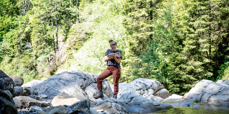
Field work is hard work
Before starting the actual field work, we clamber a little further down the gorge. We’re now at the bottom of a waterfall that towers some 10 metres above us, where a massive outcrop of Hohgant sandstone forms a slight overhang. Maira pulls out her tablet and jots down a few notes. She also uses it to measure the orientation of the rock strata, and the software plots this data directly into a digital map. “It’s a great tool, but for certain types of observations you still can’t beat a traditional field book,” she says.
Meanwhile, Stefan and Lukas are hard at work, hammering away at the hard rock to break off samples. Ideally, Maira would also like to take a sample from the upper section of the rocky overhang – but that high-hanging fruit proves too much of a challenge even for the climbing skills of the geologists. Their work is interrupted by an enthusiastic Stephan, who comes scrambling up the slope: “There are some pretty big fossils down there,” he says. “But I’m not sure if I’ve found the base of the rock formation yet.” The researchers are still uncertain as to where the boundary lies to the rock layer below. We fight our way further through the rugged terrain. The rocks in this part of the stream are polished smooth, so that the large fossils Stephan discovered are now clearly visible. “This might be the boundary between the strata,” he says. But he and Maira clearly have doubts, so we press on.
Soon, we find what we’re looking for: at the very next rocky outcrop, Lukas spots the boundary between the brown sandy rocks, which include the Hohgant sandstone, and the light-grey Schrattenkalk limestone below. A strip, only a couple of centimetres thick, marks the contact between the two strata. “There’s a gap of up to 80 million years here,” says Lukas with a grin. “The limestone was deposited around 125 million years ago, but the sandstone layer only came along around 45 million years ago.”
That means this spot next to the river spent some time at the Earth’s surface 45 million years ago before it was submerged by the ocean. During that period, rivers transported large quantities of quartz sand from the hinterland to the sea, which eventually became part of the Hohgant sandstone. But where exactly did the sand come from? It seems unlikely to have come from the nearby Aar massif, which was still covered by calcareous sediments at that time. It might have come from the Black Forest massif. Yet, the irregular grains in the sandstone would surely be much more rounded if they had travelled such a long distance.
Commissioned by swisstopo
This would be a fascinating topic for the scientists to study, but their current brief leaves little leeway to pursue it, explains Lukas. As project manager, he is responsible for keeping everything on track: “We were commissioned to carry out the study by the Federal Office of Topography (swisstopo). Their primary goal is to evaluate potential sites for quarrying suitable hard rock.” It may seem surprising that such a meticulously mapped country as Switzerland shouldn’t know exactly where to find the right kind of rock in the right quantities, but much of the current data is incomplete. Faced with looming shortages of the necessary materials, swisstopo commissioned the Georesources Switzerland Group to compile an inventory of all potential hard rock occurrences.
Stefan, who has headed the group for around four years, takes a moment during our lunch break to explain its unique role. The group was established in 2018 to replace the Swiss Geotechnical Commission (SGTK), which had been based at ETH Zurich for decades. “We get our basic funding from swisstopo and ETH Zurich, but we still have to fund part of our budget ourselves by conducting studies for industry or government agencies,” says Stefan. The group leads rather a niche existence. “Switzerland’s geology is no longer of the main focus of academic research at ETH,” says Stefan with a note of regret. “But it’s still important to keep this field alive.” As well as carrying out projects for federal offices and specialist agencies, the group is also very involved in teaching activities by providing lectures and excursions. “Maira is our first Bachelor’s student,” Stefan explains. “It’s not always easy to find suitable field areas for Bachelor’s theses. Students don’t have much time to devote to this work – and if the weather is against us, as it was this spring, then we end up running out of time.”
A heavy load
Climbing back up the hill, we soon find ourselves back where we started, in the middle of the rock section. Maira is keen to take more samples, even though the Hohgant sandstone in this area consists of nothing more than thin layers of rock interspersed with layers of clay, and is clearly unsuitable for quarrying. As Stefan and Lukas get back to hammering, Maira pulls a Schmidt hammer out of a rucksack. This device is normally employed to test the properties of concrete, but it can also be used to measure the hardness of rocks in the field. To build up a reasonably reliable picture, Maira has to measure the rebound of the hammer in various locations, striking the rock in two directions at each of 10 measurement points.
Once Stefan and Lukas have stowed the new samples in their rucksacks, we continue our climb across two more rocky outcrops. Maira also needs samples from the uppermost section, where the Hohgant sandstone again consists of thicker layers. This offers another useful example of how difficult it is to carry out measurements by the book when working in the field: unlike a vertical concrete wall, the surfaces of this rock are not flat and easily accessible. “Conditions in the field are never easy,” says Lukas with a shrug.
All in all, Maira and her supervisors have collected some two dozen large pieces of rock. It’s been a productive day, and a big step forward in her field work, but right now it’s time to carry the heavy load up the slope to the trail and back to the car. Is the Hohgant sandstone hard enough for railway ballast? Only time will tell. Maira’s next step will be to analyse the samples back at ETH – this time under clearly defined lab conditions.
This article appeared in the 21/03 issue of the ETH magazine Globe.
