“Google Earth on steroids” gives a boost to urban development
Two months ago, EPFL spin-off Uzufly moved into The Garage, a business incubator at EPFL Innovation Park where startups can grow and expand. The young firm has created virtual-reality technology that allows urban planners to map out and communicate on their development plans.
Uzufly’s system uses drones to take aerial photographs, producing thousands of images that are transformed into 3D models through the creation of digital twins, or digital replicas of real-world objects. These objects could be buildings, for example, which are georeferenced down to the centimeter. The company’s 3D models incorporate a wide range of urban-planning data and can accommodate any type of architectural design at full scale.

© 2022 EPFL Alain Herzog, Romain Kirchhoff and Théo Benazzi, Uzufly’s co-founders
Théo Benazzi, Uzufly’s co-founder and CTO, is heading up efforts to produce these high-precision digital twins. “We basically use the same technology as Google Earth – that is, ariel photography,” he says. “But while Google uses airplanes to take huge numbers of pictures at high altitudes, we use drones that have smaller cameras and capture images much closer to the ground. That’s why we can generate 3D models at the level of a neighborhood or an entire city.”
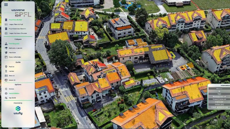
A virtual workbench
Uzufly’s digital twins can be enhanced with any kind of georeferenced data: land plots, zoning areas, urban development structures and even underground infrastructure like pipes. For example, data from Switzerland’s Federal Office of Topography can be added so that information on the solar-power generation capacity of individual rooftops is displayed right in the 3D modeling environment.

© 2022 EPFL, Uzuverse and its many data available on the platform
With all these data, Uzufly’s system is nothing less than a virtual workbench for urban planning. An architecture firm could install the system as part of their business software, download the area in which they’ve been commissioned to design a building, and begin the design process – without having to send surveyors out to get the lay of the land.
“City officials have used our system to determine how far they could extend an existing building before running into zoning limits,” says Romain Kirchhoff, Uzufly co-founder and CEO. “It’s also helped city planners figure out how a new building would fit into a given neighborhood. With our system, designers get a good feel for spaces – much better than they can from planting stakes in the ground. It makes urban planning easier and improves decision-making.”

© 2022 EPFL Alain Herzog, Romain Kirchhoff, Uzufly co-founder and CEO
and Anne Bosshard from commune d'Anières
Anne Bosshard, the head of urban planning and the environment for Anières, a town in the canton of Geneva, was looking for an effective way to explain plans for a school extension to local residents during the public consultation process. She also felt blueprints could be hard to understand and wanted a more tangible method. Uzufly’s realistic 3D images fit the bill.
“With Uzufly’s model, people gained a fuller understanding of our project,” says Bosshard. “That was true for us too, as it helped us make important choices. We could zoom out, for example, which let us see the entire area and how an extension, new building or renovation project would affect the existing urban landscape. We could see the impact on the space in question and whether views of the Alps or countryside would be obstructed.”
Video-game developers have also taken an interest in Uzufly’s technology. “What currently takes a lot of time in video-game development is modeling existing environments,” says Kirchhoff. “With our system, developers could create a version of Assassin’s Creed set right here in Lausanne, for example.”
Joint R&D with EPFL
Because Uzufly is located so close to EPFL’s main campus, the company has been able to set up joint R&D projects with several of the School’s labs. For instance, it’s working with architecture students to improve 3D models of buildings, and with the Geodetic Engineering Laboratory (TOPO) to map an avalanche by creating a 3D model of the mountain slope based on thousands of photographs.

© 2021 EPFL map an avalanche
Uzufly also has a new project in the works, with EPFL’s Arts of Sciences Laboratory (LAPIS) and the Swiss National Science Foundation. It will involve generating a model of an Egyptian temple, by fall 2023, for use in archeology and architecture research. It could eventually incorporate augmented reality to help decrypt the meaning of hieroglyphics.
