The seas are in extremis
Record temperatures in the Mediterranean.1 Huge heat wave in the North Atlantic.2 The temperature of the oceans at an all-time high.3 The ocean’s fever chart has been covered in the media since early summer. While this was probably the first time many people in Switzerland had heard of marine heat waves, these reports came as little surprise to me.
As climate scientists, we understand very well how human-induced global warming is also pushing up ocean temperatures. The ocean is the primary thermal buffer in the Earth’s climate system, absorbing more than 90 percent of the additional heat resulting from greenhouse gases such as CO2. So, in and of itself, it’s not surprising that marine heat waves are becoming more frequent and intense.4 But I have to admit that I wasn’t prepared for what’s currently happening in the oceans: the intensity and magnitude of the heat waves is enormous, and the rapidity of the warming fills me with concern.
In uncharted territory
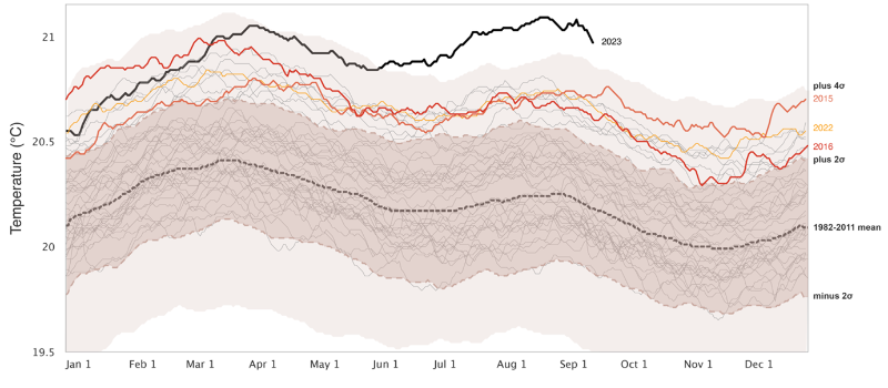
In recent weeks, the global average temperature of the sea surface has reached 21.1 degrees Celsius – the highest ever recorded. That’s 0.3 degrees warmer than the previous record temperature at this time of year. Since the spring, the temperature curve for 2023 has been about 1 degree above the 1982–2011 average.
Without a doubt, the current sea surface temperatures are way out of the ordinary. The ocean is moving in uncharted territory – and climate science is struggling to anticipate these movements.
A product of various factors
We don’t yet fully understand the factors that have caused ocean temperatures to jump to these new highs. Certainly, the emerging El Niño event is an important driver. We know from past experience that an El Niño increases the global average sea surface temperature by about 0.1 to 0.2 degrees Celsius. However, this effect tends to come later in the year, when El Niño reaches its peak around the turn of the year.
Furthermore, we’re currently observing two huge heat waves in the North Pacific and the North Atlantic, which got underway at the beginning of the year and have intensified and expanded in recent months. This combination of El Niño and extratropical heat waves is driving up global ocean temperatures tremendously, especially since hardly any ocean region is significantly cooler than normal at present.
A perfect storm
The question is, did this combination of factors occur by coincidence – or is there something driving it? In my assessment, much of it is in fact coincidence. El Niño may well have amplified the North Pacific heat wave, similar to what happened during the monster North Pacific heat wave known as “the Blob” from 2013 to 2015. But there’s no evidence linking El Niño to the North Atlantic heat wave.
I therefore argue that we’re dealing with a perfect storm – an extraordinary situation where various factors happen to come together in such a way that they reinforce each other. However, it’s also important to note that without human-induced global warming, this perfect storm could never have generated such high temperatures.
Stable high-pressure conditions promote heat waves
So, while a marine heat wave’s timing is largely random, there are conditions that favour its formation. These include stable high-pressure systems – extensive regions of good weather that can persist for long periods of time and thus promote heat waves, both on land and at sea.
Atmospheric and oceanic circulation outside the tropics play an important role here. “Circulation” refers to large-scale currents, such as the jet stream in the atmosphere or the meridional overturning circulation in the North Atlantic.
In an ideal world, we could model future circulation patterns to identify favourable conditions for heat waves early on. Unfortunately, the circulation patterns underlying stable high-pressure systems can’t be predicted much beyond a few days or a few weeks at most. This is mainly due to small-scale turbulence, which is the reason two possible weather developments with only small differences in initial or boundary conditions can rapidly drift far apart; the phenomenon is often referred to as the butterfly effect.
So, if we can’t determine individual occurrences, we should at least be able to predict whether a warmer climate will cause such stable circulation patterns to occur more often and for longer periods – in other words, whether conditions that could promote heat waves will become more frequent. But therein lies the rub.
Blurred circulation
There is little consensus among climate scientists on this question, just as we can’t predict whether El Niño will become more frequent or more infrequent in the future. We also don’t really agree on whether or not the meridional overturning circulation in the North Atlantic will weaken much. Or whether the jet stream in the atmosphere will be altered. These are all relevant questions that have a strong impact on exactly how climate change will affect different regions of the world.
A common challenge underlying all these questions is that both atmospheric and oceanic circulation are not only determined by large-scale processes, but also substantially modified by small-scale processes. These are weather processes such as convection, cloud formation, thunderstorms or storms – processes that take place on scales of one to a few kilometres. In other words, circulation is a phenomenon determined by interactions among all spatial scales.
But it is precisely these scale interactions that the climate models we typically use today don’t simulate. This is primarily because the resolution of the models is too low. With today’s grid spacing of around a hundred kilometres, the models aren’t fine enough to correctly represent many elementary processes of weather in the atmosphere or the ocean. And yet it’s exactly these kinds of small-scale weather processes that strongly influence large-scale weather situations (and vice versa). At present, we generally have to estimate them or model them using highly simplified methods, which leads to sizeable uncertainties.
That means the challenge is still on for climate and weather researchers to develop their models further, especially with respect to the resolution and accuracy, with which we can map changes in circulation and thus changes in weather patterns. We at ETH Zurich are working on this together with MeteoSwiss in the EXCLAIM project6 and on an international level with EVE.7
We expect this to lead to a more detailed understanding of circulation and ultimately to more consensus on the big questions in climate research. And most importantly, we need to increase the accuracy of local and regional assessments of climate change so we can work out how best to adapt.
