50 years of recording storm damage in Switzerland
At the beginning of this decades-long data collection, the intention was to show the need for methods for torrent and slope control. For this reason, the former Swiss Federal Institute for Forest Research (EAFV) (today's Swiss Federal Institute for Forest, Snow and Landscape Research WSL) began to record all damage caused in Switzerland by naturally occurring floods, debris flows and landslides. The primary basis for this, then as now, was comprehensive media monitoring.
After severe weather events in 1977/78 and 1987, new federal laws on hydro-engineering and forests were drafted, which obliged the cantons to draw up hazard maps and registers. Thus, a damage overview provided according to uniform principles gained further importance. Hence, the storm damage database was continued on behalf of the Federal Office for the Environment FOEN and, from 2002 onwards, rockslide events were also included in the catalogue.
We have now worked through the damage intensive year 2021 and recorded the fall events (rockfall, rockslides and landslides) for the years 1972 to 2001 retrospectively by using archives. Today, we have a 50-year data series for damage caused by floods, debris flows, landslides and rockslides.
Largest damages in 1987 and 2005
Since 1972, more than 27,000 database entries have recorded damage costs of a good 15 billion Swiss francs. The highest costs by far are caused by floods: almost ninety percent of the damage sum can be traced back to them. The map view shows that hardly any municipality has been spared in the last 50 years.
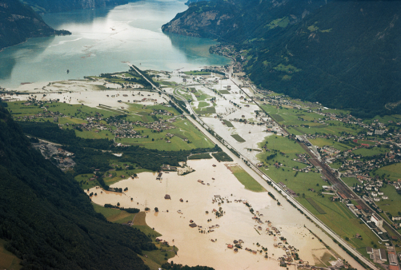
However, a few major events are responsible for the lion's share of the damage costs. The most damaging flood of the last 50 years took place on 21 and 22 August 2005. It caused damage of around three billion Swiss francs and affected almost every third municipality in Switzerland. The second worst storm, which occurred in the summer of 1987, cost a good CHF 1.1 billion (adjusted for inflation) and mainly affected the Alpine region, with major damage in the cantons of Uri, Ticino and Grisons.
Hazard maps and environmental monitoring
Who benefits from knowing such facts? Municipalities and engineering offices use information on damage events, among other things, to draw up hazard maps, and these must be updated regularly. In addition, the storm damage database is used in research. It is also used for the FOEN's indicators on the state and development of the environment: Two of the eight indicators on natural hazards draw information from it.
In general, damage can be prevented or limited especially if hazards are known. It is therefore of central importance that information on past events is collected and available. The data series on storm damage in Switzerland can thus be understood as a collective memory.
Collecting information since 1972
The Swiss Federal Institute for Forest, Snow and Landscape Research WSL has been systematically collecting information on storm damage since 1972. The database, which was compiled with substantial support from the Federal Office for the Environment FOEN, contains information on damage caused by floods, debris flows and landslides, as well as rockfalls, rockslides and landslides. Damage resulting from avalanches, snow pressure, earthquakes, lightning, hail and storm winds is not taken into account in the evaluations. The estimation of property, infrastructure, forest and agricultural damage is mainly based on media reports. The data are available to experts on request and form an important basis for hazard assessment. The survey of extreme weather damage by WSL is used for environmental reporting by the Federal Office for the Environment FOEN.
